TOPO4D Drone Services

From Land Surveying to Drone mapping
Our journey from traditional total station surveying to embracing drone services has been a remarkable evolution. Over the years, we’ve transitioned from manual ground surveys to harnessing the power of advanced drone technology. This transformation has not only significantly improved our efficiency but has also allowed us to offer clients faster, more accurate, and comprehensive solutions for their surveying and mapping needs.

About TOPO4D
Topo4D is at the forefront of modern surveying and mapping. Starting as land surveyors, we’ve evolved into specialists in drone technology. With over five years of experience, we combine traditional expertise with cutting-edge drones to provide topographic maps, thermographic inspections, and concrete assessments.
Our commitment to precision and innovation sets us apart. We serve a diverse range of clients, from construction and architecture to infrastructure inspections. At Topo4D, we’re redefining spatial intelligence for a more accurate and efficient future. Explore our services and join us in shaping tomorrow’s landscape.
“Precision in every pixel, innovation in every flight, and excellence in every map.” – Topo4D
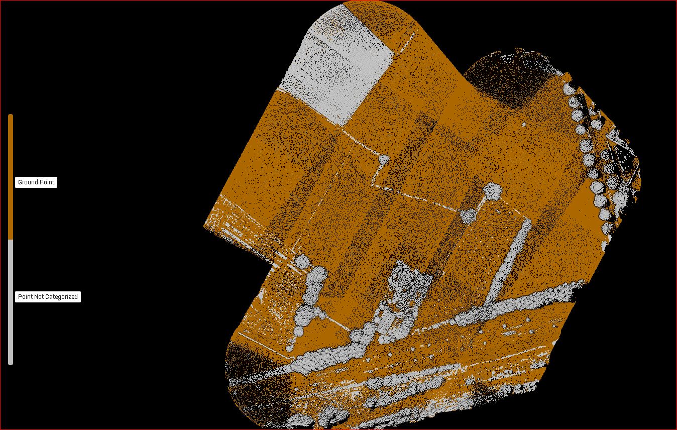
Mapping
Welcome to TOPO4D.com Drone Services. We are the leaders in modern surveying and mapping, using cutting-edge drone technology to provide topographic maps, thermographic inspections, and concrete assessments. With over five years of experience, our commitment to precision and innovation sets us apart. Join us in shaping tomorrow’s landscape with our accurate and efficient services. Contact us today!
Inspections
At TOPO4D.com Drone Services, we take pride in providing comprehensive inspections using state-of-the-art drone technology. Our team of experts is equipped with cutting-edge drones to conduct thorough inspections that deliver accurate results. Whether it’s for land surveying, infrastructure assessments, or thermal imaging, our inspections are conducted with precision and efficiency. We are committed to redefining spatial intelligence and shaping tomorrow’s landscape. Join us in experiencing the precision in every pixel, innovation in every flight, and excellence in every map. Contact us today to learn more about our inspection services.

Thermal
Discover a new perspective with our cutting-edge thermal drone services. Experience the power of thermal imaging technology as we uncover hidden details, identify energy inefficiencies, and provide invaluable insights. From inspections to assessments, our expert team at TOPO4D.com Drone Services has the precision and expertise to deliver accurate and reliable thermal solutions. Join us in exploring the unseen and revolutionizing the way you see your world.

Construction mapping
Drones streamline construction site management through aerial surveys, progress tracking, and site analysis, ensuring efficient project management and timely decision-making.
Outdoor Inspections
In sectors like infrastructure and energy, drones excel in inspecting vast outdoor assets like pipelines, power lines, and bridges, reducing downtime and ensuring structural integrity.
Thermal
In the field of thermography, drones provide a safe and efficient means to identify temperature variations, enabling early detection of issues in electrical systems, building envelopes, and more.
Agriculture & Forestry
Drones aid in precision agriculture by offering real-time crop monitoring, disease detection, and yield prediction, optimizing farming practices and resource utilization.
FPV (First-Person View) Flights / Cinematic
FPV drones are a valuable tool for aerial photography, cinematography, and immersive experiences, catering to the entertainment and media industry’s creative needs.
Indoor Inspections / Confined space
In confined spaces, drones navigate and inspect hard-to-reach areas, enhancing safety and reducing the need for manual inspections in industries such as manufacturing and utilities.
new projects/year on avarage
drones in the air

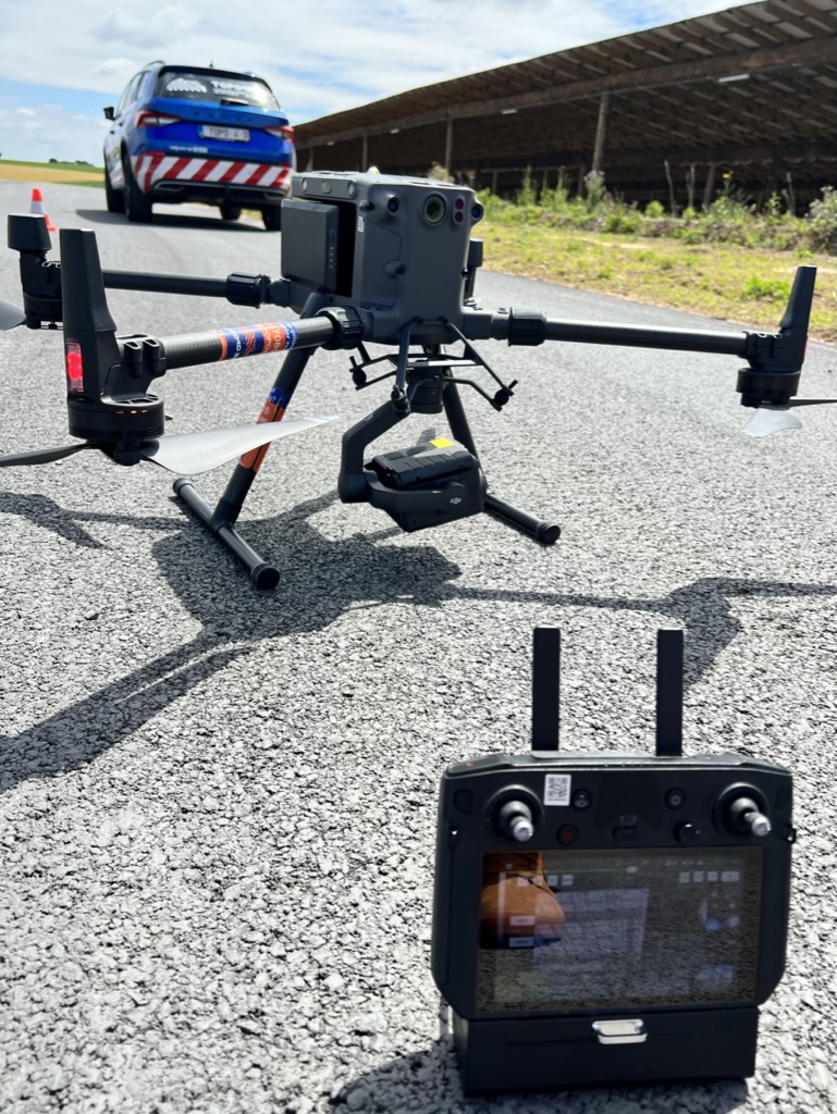
Selecting Topo4D is choosing excellence in drone services. With over half a decade of experience, we stand as seasoned pioneers in the field. Our distinct advantage lies in our diverse fleet of 12 specialized drones, meticulously tailored for a spectrum of operations.
Our unwavering commitment to precision and innovation drives us to consistently exceed expectations. Whether it’s comprehensive topographic mapping, meticulous thermographic inspections, or detailed concrete assessments, we tailor our solutions to your project’s unique needs.
At Topo4D, we don’t just promise results; we guarantee them. Our team’s expertise combined with state-of-the-art technology ensures you receive superior data quality and efficiency in every engagement. When you choose Topo4D, you’re choosing a partner dedicated to providing accurate, efficient, and cutting-edge solutions for all your surveying and mapping requirements. Join us in shaping a future defined by excellence.

Flying Since
2013
We pioneered the use of smaller drones in our testing phase, perfecting our techniques to ensure precision and efficiency. From topographic maps to thermographic inspections and concrete assessments, our innovative approach sets us apart as leaders in the industry. Join us in shaping tomorrow’s landscape with our accurate and reliable services. Contact us today!
With over five years of invaluable experience, we are committed to delivering unparalleled precision and innovation. Join us in shaping the future of mapping with our unrivaled accuracy and efficiency. Get in touch with us today and experience the pinnacle of drone services excellence!

Engineering
At TOPO4D.com Drone Services, we’re at the forefront of industry advancements, leveraging cutting-edge technology to revolutionize surveying and mapping. Our automated drone flights ensure swift data collection, reducing time and costs. Through AI-powered annotation inspections, we provide precise assessments, while our spot analysis techniques deliver granular insights. These developments mark our commitment to enhancing efficiency, accuracy, and innovation in every project we undertake.


TOPO4D Drone Services has revolutionized the world of surveying and mapping with cutting-edge drone technology. Our team of experts merges traditional expertise with modern innovation to provide topographic maps, thermographic inspections, and concrete assessments. With over five years of experience, we are at the forefront of spatial intelligence, serving clients from construction and architecture to infrastructure inspections. Join us in shaping a more accurate and efficient future with TOPO4D.com Drone Services.
As a land surveyor at TOPO4D.com Drone Services, I am thrilled to be part of a team that is revolutionizing the world of surveying and mapping. With our cutting-edge drone technology and over five years of experience, we are at the forefront of spatial intelligence. Our commitment to precision and innovation sets us apart, allowing us to provide topographic maps, thermographic inspections, and concrete assessments that exceed our clients’ expectations. Join us in shaping a more accurate and efficient future with TOPO4D.com Drone Services.
“I’m proud to lead a team that’s reshaping the surveying and mapping landscape. With our state-of-the-art drone technology and five years of expertise, we’re pioneers in spatial intelligence. Our unwavering dedication to precision and innovation differentiates us, enabling us to deliver topographic maps, thermographic inspections, and concrete assessments that consistently exceed client expectations. Join us in shaping a future of unparalleled accuracy and efficiency with TOPO4D.com Drone Services.”
TOPO4D.Com
Drone Services
A TOPO4D bv Company